May 2025


Shawn MacMenamin,
LSPS President
PRESIDENTIAL PRIVILEGE
Dear LSPS Members,
I would first like to thank everyone for their support and participation. I would like to thank Jeff Messinger, the past president, for his hard work and dedication to moving the society forward. Thanks to everyone who made this year’s annual convention a success. I would especially like to express my gratitude to Mrs. Liz Kearney, LSPS Executive Administrator, for her tireless work in keeping the organization running smoothly.
It is a great honor to become LSPS President. I started attending district meetings when I was in college and never imagined that one day I would have the privilege of leading our organization. Over the years, I have made a lot of great connections and friends through LSPS.
I would like to continue the work and philosophy that Jeff started. One day, he came to me with the idea that we must do more as a board to represent the profession. For years, the board worked primarily on smaller issues, but under the leadership of Jeff, we started to tackle larger, more vital issues. For example, we are working to modernize the definition of surveying in the statutes. This has been an arduous task over the last few years. Additionally, I would like to continue the conversation about updating the standards of practice. Also, we started getting more involved legislatively over the previous few years. We now have a board attorney along with our lobbyist.
I would like to have some participation from membership for the legislative committee this year. There are a few bills in the state legislature that we are currently watching that have the potential to affect our profession. Please contact me or Derick Wheat if you would like to volunteer.
I am looking forward to serving as LSPS President for this next term. Together, we will continue to move forward to protect and advance our profession.
Please contact me or your District Chairman with any ideas or questions you may have. Thank you for this honor and privilege.
Sincerely,
Shawn MacMenamin
64th Annual LSPS Convention
Held at the Golden Nugget – Lake Charles, LA

Spouses at Flock of Five
In April 2025, the Louisiana Society of Professional Surveyors (LSPS) hosted its 64th Annual Convention at the Golden Nugget Hotel & Casino in Lake Charles. The three-day event brought together nearly 400 surveyors, exhibitors, educators, and students from across the state, marking a strong turnout and continued growth for the LSPS community.
The convention offered a dynamic combination of continuing education, professional networking, and social engagement. Attendees participated in technical sessions, learned from industry experts, and enjoyed valuable time reconnecting with peers and colleagues.

Charcuterie boards made by spouses at Bayou Boards
Golf, Ethics, and a Strong Start
The event officially kicked off on Wednesday with the Annual LSPS Golf Tournament at The Country Club at the Golden Nugget. Participants, including students from Nicholls State and Louisiana Tech, enjoyed a competitive but friendly afternoon on the course, with student volunteers helping manage logistics and registration.

Guided wine tasting
That evening, the first educational session of the convention was held—an ethics presentation led by Stephen Flynn, PLS. This session set the tone for the days ahead, highlighting professionalism and responsibility as core values in the surveying field.
Spouse Tour Offers a Day of Fun and Flavor
While surveyors attended Thursday’s education sessions, spouses enjoyed a thoughtfully curated day exploring local highlights. The tour began with gourmet coffee and beignets at Coffee:30, followed by shopping at the charming Flock of Five Gift Emporium in Sulphur. Next, the group dined at Area 337, a Latin American restaurant known for its flavorful dishes and warm hospitality. The afternoon included a stop at Accessory Zone for boutique shopping, a guided wine tasting at The Wine Store led by a knowledgeable sommelier, and a hands-on charcuterie-making class at Bayou Boards by Gabrielle. Each participant left with their own custom charcuterie board—and plenty of new memories from a day filled with laughter, connection, and creativity.
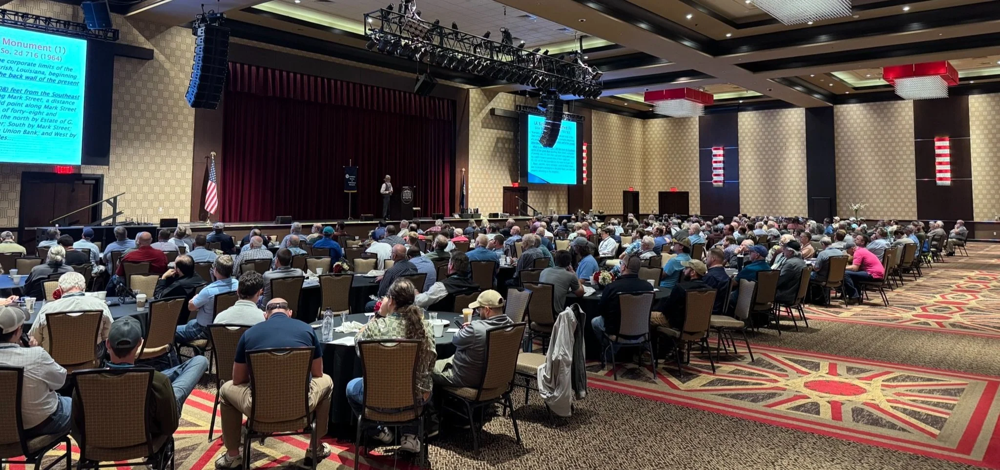
One of the sessions in progress
Thursday: A Deep Dive into Legal Nuance
Thursday’s full-day session featured “When the Rules Don’t Work,” taught by Kris Kline, PLS. This comprehensive course offered a “smorgasbord” of topics across retracement and real estate law. Each segment began with a widely accepted surveying “rule,” followed by in-depth discussions of its exceptions, caveats, and limitations. Topics included riparian standards, rules of construction, acquiescence & common scheme, and the doctrine of merger. Attendees praised the session for its relevance, clarity, and practical applications.
Educational updates from Nicholls State University and Louisiana Tech were also shared, demonstrating continued investment in the next generation of surveyors and strong collaboration between academia and the profession.

Exhibit Hall
Executive Board and New Leadership
During the General Business Meeting on Friday morning, new LSPS board members were officially sworn in. Congratulations to the incoming leaders! Their leadership and commitment will help drive the organization’s mission forward in the year ahead
Social Highlights
The Exhibit Hall Reception on Wednesday evening allowed attendees to meet sponsors and exhibitors while enjoying complimentary drinks, hors d’oeuvres, and music. Members gathered at the Blue Martini on Thursday night for the always popular Surveyor’s Social. Attendees enjoyed gumbo, sliders, and great company in a relaxed and festive atmosphere.
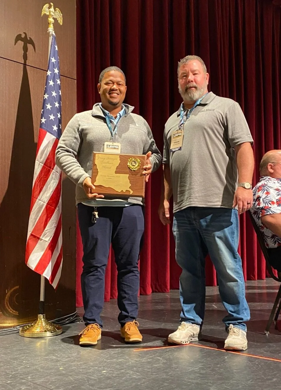
Devon Richard receives the Young Surveyor Excellence Award
Annual Meeting, Awards, and Final Sessions
Friday began with the LSPS Annual Business Meeting, where members reviewed society business and celebrated professional excellence. This year, Devon Richard, PLS, received the Young Surveyor Excellence Award.
The educational program continued with Tony Cavell's presentation on The New State Plane Coordinate System. This timely session offered critical insights into evolving sea level data and its impact on surveying practices.
The convention concluded with two final presentations:
Standards of Practice – Louisiana, taught by Ryan Estess, PLS
Standards of Practice – Mississippi, taught by Joe Byrd, PLS
Looking Ahead
The 64th Annual LSPS Convention was a resounding success, reflecting the strength, knowledge, and camaraderie of Louisiana's surveying community. LSPS extends its gratitude to the sponsors, speakers, volunteers, students, and members who made this event possible.
We look forward to welcoming you back for the 65th Annual Convention, which will take place April 15–17, 2026! See you there!
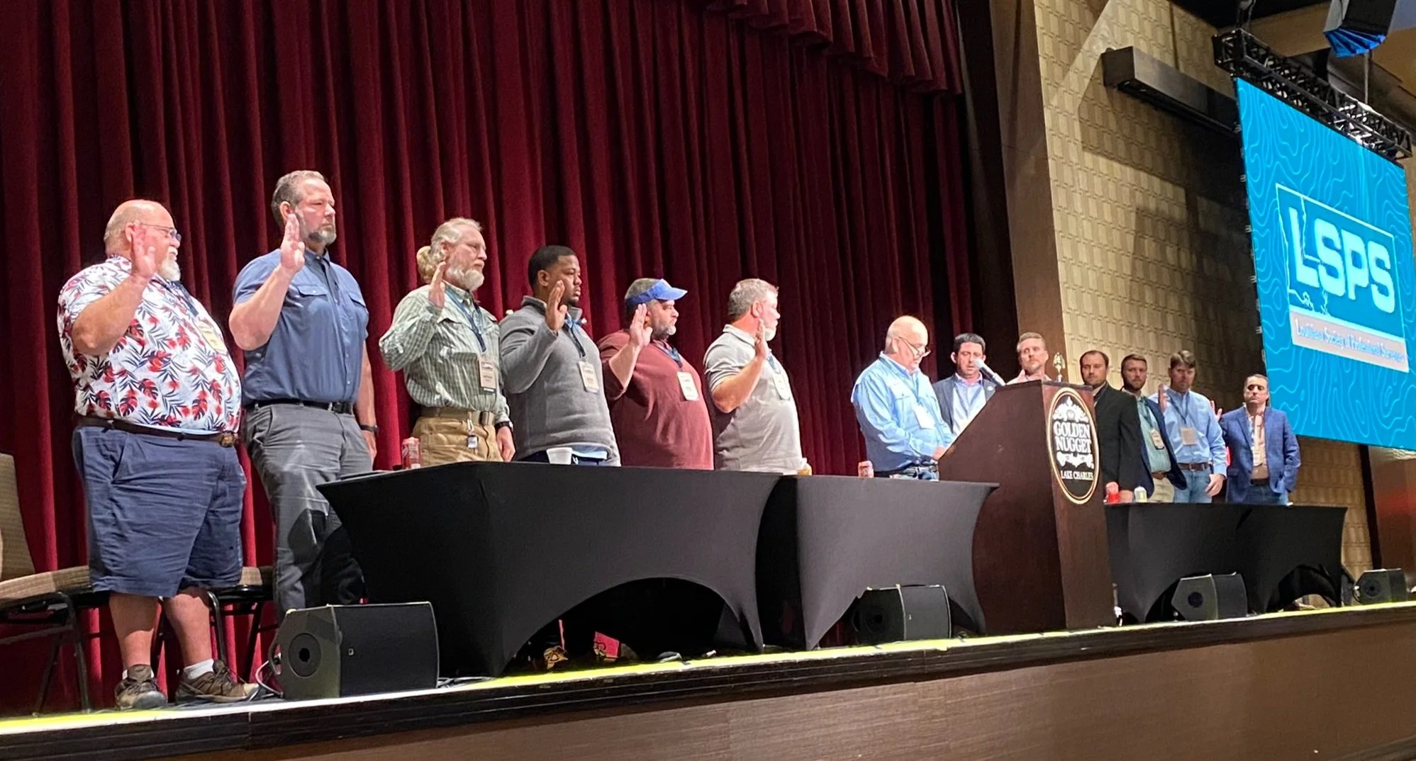
The board was sworn in by outgoing President, Jeff Messinger
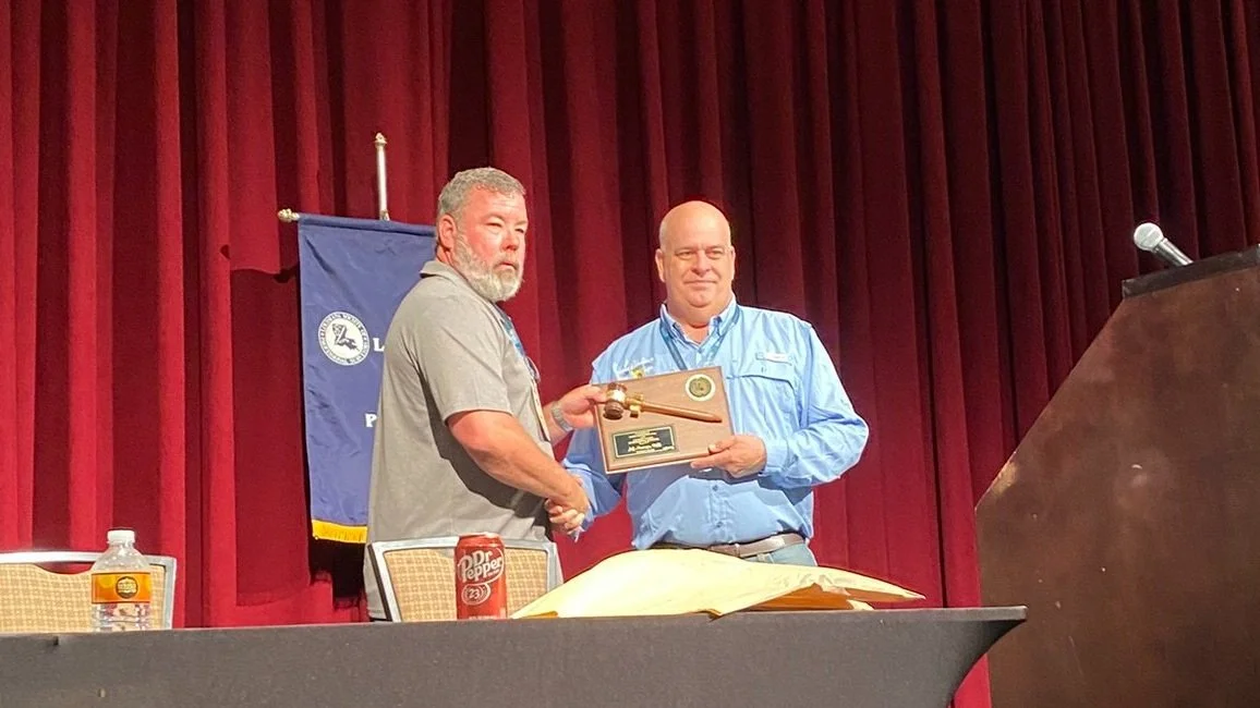
Incoming President, Shawn MacMenamin, presented Jeff Messinger with the President’s Gavel

LOUISIANA 811
Click below to access a document that outlines the Pre-Design Ticket process now available through Louisiana 811, which allows surveyors and designers to access underground utility and facility information during the early planning stages of a project.

Blair’s Boundary Blog
By Blair Naquin,
Law Offices of R. Gray Sexton
We have been asked to provide relevant legal analysis in response to the two scenarios –with multiple offshoots – that surveyors often “encounter” regarding the Standards of Practice (formerly known as Minimum Standards). Descriptions of these scenarios and our responses are included below.
While these questions do not involve the interpretation of a particular statute or controlling case law, the interpretation of administrative standards, best practices, and industry standards is of equal significance and importance and has formed the cornerstone of our firm’s practice for half a century. Our experience with multiple licensing boards warrants the conclusion that most turn a deaf ear to the defense that compliance was “impossible” because of commercial considerations – typically that the fee paid was insufficient to enable the professional to perform the requisite services “the right way” in accordance with controlling guidelines.
I. Scenario One:
The question is, in essence: If you are hired to do a boundary survey, and all of the corners are out-in-the-open, and you do not physically walk the lines between the corners, is it a violation of the Standards of Practice to provide the client with a Map of Survey and/or a property description?
For example: A client owns the tract depicted below:

The client hires the surveyor to conduct a boundary survey. As reflected in the above illustration, two of the lines intersect briar thickets,” and one of the lines intersects thick woods. Since all of the corners are “out-in-the-open,” the surveyor does not “walk the lines.” The reasons for the surveyor not doing so are many, but are not part of this issue. The surveyor draws a Map of Survey, signs it, and furnishes it to the client.
The issue is if – again, for whatever reason(s) – the surveyor does not walk each line (to observe visible evidence of possible encroachments, etc.), is that surveyor’s Map of Survey in violation of the Standards of Practice?
Response:
While the Standards of Practice are considered to be relatively subjective, it is important to recall that these standards were previously known as Minimum Standards. The Standards of Practice set the minimum threshold that surveyors must meet in the performance of their work, yet without limiting surveyors’ obligations in any way, as reflected in the following excerpt from Section 2901:
B. The purpose of these standards of practice is to safeguard life, health and property, and to promote the public welfare, by establishing technical standards of practice for every boundary survey performed in Louisiana so that professional performance can be evaluated for but not limited to research, field work, monuments, descriptions, plats and maps. If higher standards are required by clients, or by local, state and federal jurisdictions, then those standards shall govern. When a boundary survey involves certain corners or lines that are covered under the appropriate edition of the Manual of Instructions for the Survey of the Public Lands of the United States, then the manual's rules or instructions for these particular surveys shall apply. Every professional land surveyor performing a boundary survey in Louisiana is required to follow these standards.
46 LAC Pt LXI, § 2901 (emphasis added).
Further, Section 2907 (F) of the Standards of Practice provides, in relevant part, as follows:
6. All boundary discrepancies, visible evidence of possible encroachments, and visible indications of rights which may be acquired through prescription or adverse possession shall be physically located. All evidence of servitudes that is visible without meticulous searching shall be physically located during the survey. Furthermore, nonvisible servitudes shall be located only upon the client's specific request and the client's delivery of any necessary documentation.
7. All field data gathered shall satisfy the requirements of the following Subsection on plats and maps.
46 LAC Pt LXI, § 2907 (emphasis added).
Because Section 2907(F)(6) requires that, “[a]ll boundary discrepancies, visible evidence of possible encroachments, and visible indications of rights which may be acquired through prescription or adverse possession shall be physically located,” the surveyor in the above-described scenario should walk the boundary lines and “physically locate[]” the “visible evidence of [these] possible encroachments.”
Although a surveyor may seek to avoid physically walking the boundary lines in an effort to minimize the time and expense associated with performing the survey, commercial considerations are not an adequate defense to compliance with the Standards of Practice. To comply with the Standards of Practice, the surveyor in Scenario One should be sure to walk the boundary lines and physically locate the briars and thickets and woods for inclusion in the Map of Survey.
Follow-Up Question:
What if the client tells the surveyor he/she only wants a “stamped description,” as described in Section 2907(H), below?
H. Descriptions. A written legal description of the surveyed tract of land shall provide information to properly locate the property on the ground and distinctly set it apart from all other lands. ...
46 LAC Pt LXI, § 2907.
Response:
While there is no defined “criteria” for designating any encroachments in a “description,” a cautious interpretation of the Standards of Practice suggests that, if a surveyor only provides a stamped description without walking the lines, such a surveyor would violate the spirit, if not the letter, of the Standards. To comply with Section 2907(F), the surveyor should, instead, walk the boundary lines to physically locate the encroachments.
Follow-Up Question:
In this scenario, the client hires the surveyor to “ONLY mark my corners,” stating, “I do not need or want a Map of Survey; I just want to know where my corners are.” Then, six months later, the client comes back to the surveyor and says, “Can you draw me a map of that tract you marked my corners on last year?” Would furnishing a Map of Survey without doing any more field work violate the Standards of Practice?
Response:
Under the same rationale set forth above, a prudent surveyor would walk the boundary line and physically locate all encroachments to ensure compliance with Section 2907(F).
II. Scenario Two:
Surveyor A conducts a boundary survey of an 80-acre tract of property for a client. Some years later, the property owner goes to a different surveyor, Surveyor B, gives that surveyor the first surveyor’s Map of Survey, and says he wants Surveyor B to divide the 80-acre-tract into two 40-acre tracts, so he can donate one to each of his two children.
Can Surveyor B go out into the field and create line A-B, BUT, draw a Map of Survey of both Tracts A and B, as shown in the below sketch?
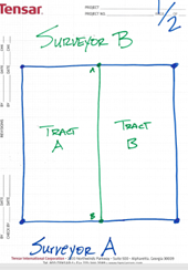
What if Surveyor B puts the following note on his plat? “The boundary of Tracts A and B were surveyed previously by Surveyor A on <date>. The undersigned surveyor only surveyed line A-B to establish Tracts A and B.”
Response:
To comply with the letter and spirit of the Standards of Practice, the surveyor should re-survey the entire boundary first, then divide it via line A-B.
Section 2901(E) provides:
E. When in the professional land surveyor's opinion, special conditions exist that effectively prevent the boundary survey from meeting these standards of practice, the special conditions and any necessary deviation from these standards shall be noted upon the drawing. It shall be a violation of this Chapter to use special conditions to circumvent the intent and purpose of these standards of practice.
46 LAC Pt LXI, § 2901(emphasis added).
Thus, Surveyor B in the above-described Scenario Two would violate Section 2901(E) by attempting to use a note to circumvent the requirements of Section 2907(F).
Similarly, a surveyor’s note on a Map of Survey stating, “Not all the boundary lines were physically walked, per the client’s request,” is likely insufficient to excuse a failure to “physically locate[]” “[a]ll boundary discrepancies, visible evidence of possible encroachments, and visible indications of rights which may be acquired through prescription or adverse possession,” as required by Section 2907(F).

Such a note stands in contrast to a similar, yet acceptable, type of note that surveyors sometimes use, when applicable, stating, “Not all topographic features were located, per the client’s request.” This type of note is acceptable because the Standards of Practice do not require that ALL topographic features, THAT ARE NOT VISIBLE ENCROACHMENTS, must be located (and/or shown). For example, this note could be permissibly used to explain why a house in the middle of a client’s tract is not shown on a Map of Survey.
Conclusion:
While practical and commercial considerations sometimes present challenges to compliance with certain aspects of the Standards of Practice, it is important for surveyors to remain mindful of these cardinal requirements and comport with all applicable aspects of these Standards. Surveyors should take care to comply with both the letter and the spirit of the Standards of Practice.
LSPS DISTRICT INFORMATION

District 1
John Teegarden
jteegarden@ascellc.com
District 2
Derek Martin
dmartin@apexsurveyllc.com
District 3
Devon Richard
drichardsurveying@gmail.com
District 4
Jason Tuggle
Jason_tuggle@hotmail.com
District 5
Joey Riggin
jriggin@lazenbyengr.com
District 6
Derek Wheat
derek.wheat@yahoo.com
District 7
Jules Toups
jules.toups@la.gov
District 8
Matt Phillips
matt@lodestone.biz
District 9
Cory MacMenamin
cmacmenamin@ddgpc.com
District Announcements:
DISTRICT 2 - Derek Martin, Chairman
New officers were voted on and approved. Chairman: Mr. Derek Martin, Vice-Chairman: Mr. Jacob Callais, Treasurer: Mr. Jacob Rodrigue
SOUTH LOUISIANA COMMUNITY COLLEGE
MAY 2025
By: Michael O’Pry
We just finished up the semester, all grads are placed working.
We also completed and passed our 3-year ATMAE accreditation review with a site visit, thanks to our advisory committee. We are looking forward to the fall semester starting!
LEGISLATIVE UPDATE
By: Harper Duncan & Associates, LLC

As we approach the midpoint of the 2025 Regular Legislative Session, several bills of interest to the land surveying profession are progressing through the legislative process. Below is an updated summary of key legislation, including recent actions and potential impacts on our field.
Key Bills Impacting Land Surveyors
HB 312 – Qualifications-Based Selection for Professional Services
• Author: Rep. Foy Gadberry
• Status: Pending Senate Final Passage
• Summary: Prohibits state and local agencies from using price or price-related information as a selection criterion for architects, engineers, landscape architects, and land surveyors. This reinforces qualifications-based selection practices.
HB 446 – Judicial Review of Land Use Decisions
• Author: Rep. Annie Spell
• Status: Pending in Senate Local & Municipal Affairs Committee
• Summary: Clarifies the judicial review process for local land use decisions, specifically focusing on subdivision approvals. It aims to streamline and standardize the legal review process for local land use decisions while preserving the discretionary power of local planning authorities.
HB 528 – Reorganization of the Department of Transportation and Development (DOTD)
• Author: Rep. Ryan Bourriaque
• Status: Passed House; pending Senate Transportation, Highways, and Public Works
Committee
• Summary: Proposes a comprehensive reorganization of the DOTD, including creating new offices and shifting responsibilities among leadership.
HB 603 – Changes to Occupational Licensing Board Appointments
• Author: Rep. Dixon McMakin
• Status: Pending Senate and Governmental Affairs
• Summary: Revises the appointment process for 31 occupational licensing boards and commissions, changing the requirement that the governor appoint from a submitted list to a recommendation-based process.
SB 35 – Legal Servitudes
• Author: Sen. Ed Price
• Status: Passed Senate; pending House final passage
• Summary: Reorganizes and clarifies servitude law by moving relevant provisions from the Civil Code into the Revised Statutes, separating them into categories for utility servitudes and rights of passage for enclosed estates.
SB 126 – School Mapping Data Requirements
• Author: Sen. Caleb Kleinpeter
• Status: Passed Senate; pending House Education Committee
• Summary: Establishes requirements for creating and sharing detailed digital maps of public school buildings and facilities to improve emergency response capabilities.

WE NEED YOUR HELP!
Your generous contribution is needed to support the following funds:
1.The Education Foundation, grants scholarships while providing guidance by assisting worthy students to obtain instruction and training in land surveying and higher education.
2.The Every Member Campaign (EMC), which began in 2006, was created solely for the purpose of supporting the Geomatics Program at Nicholls State University.
3.The Disaster Fund, which stands ready to give relief when disaster hits our area.
4.The Legislative Fund, allowing us to be ready to address legislation affecting our Surveying Profession.
Click here for DONATION OPPORTUNITIES
Or find the link at the top of our home page at www.lsps.net
JOIN LSPS:
The Louisiana Society of Professional Surveyors is organized to enhance the Surveying Profession. Our goal is to carry out our mission by maintaining high technical and cultural standards in our field, working with educational institutions for the maintenance of high standards of education in Land Surveying, requiring a high standard of ethical practice by our members, and encouraging the personal and professional development of young Land Surveyors.

WE’D LOVE TO FEATURE YOUR SURVEYING PICTURES IN OUR NEWSLETTER!
Click the link below to submit your photos.